Twenty Five Years
of Island Images - May 2000 - 2024
|
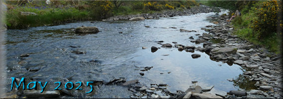
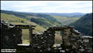
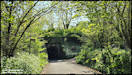
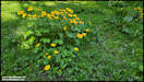
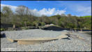
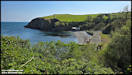
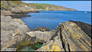
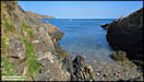
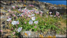
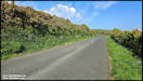
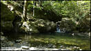
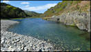
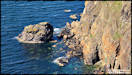
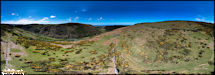
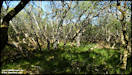
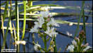
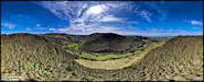
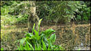
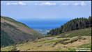
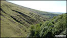
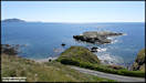
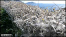
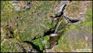
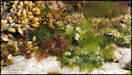
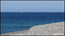
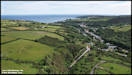
2/5/25
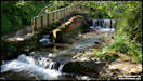
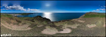
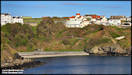
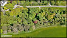
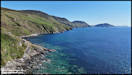
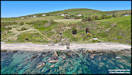
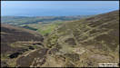
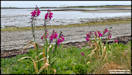
Sometimes when I go
out, I plan to take a whole set of pictures, other times I think that I
might get just one or two to share, but end up with loads.
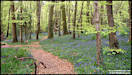
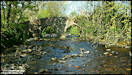
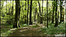
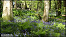
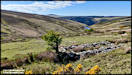
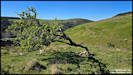
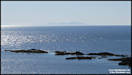
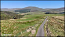
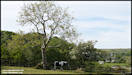
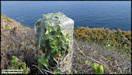
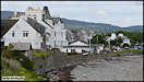
This selection is the
latter, I just went for a walk at Port Soderick Glen, but ended up extending
it to the headlands with lots of pictures taken!
Samsung S24 Ultra
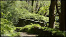
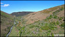
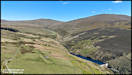
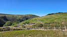
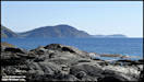
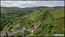
1/5/25
 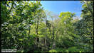   
    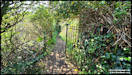
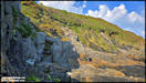  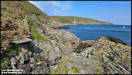  
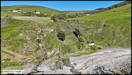
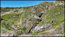
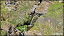
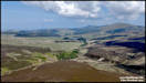
     4/5/25 - May the
Forth be with you!
Another set of pictures
from a walk. I did this one on Friday afternoon, starting from the
top of Ballaglass Glen, then walking down through the glen and onto the
old pack horse road that takes you down to Port Cornaa, before returning
via the same route. Not too far in distance at just over 3.5 miles,
with a drop/climb of 325 ft.
Panasonic FZ82
2/5/25
4/5/25 - May the
Forth be with you!
Another set of pictures
from a walk. I did this one on Friday afternoon, starting from the
top of Ballaglass Glen, then walking down through the glen and onto the
old pack horse road that takes you down to Port Cornaa, before returning
via the same route. Not too far in distance at just over 3.5 miles,
with a drop/climb of 325 ft.
Panasonic FZ82
2/5/25
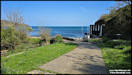
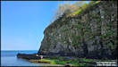
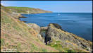
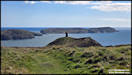
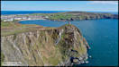
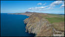
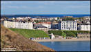
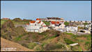
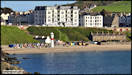
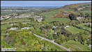
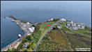
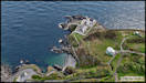
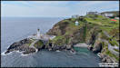
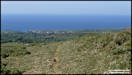
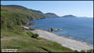
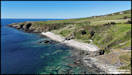
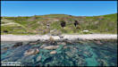
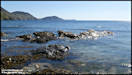
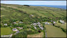
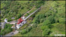
     5/5/25
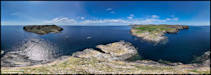
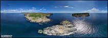
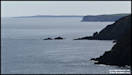
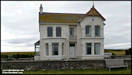
Yesterday afternoon
we went for a walk to Bradda Head, Port Erin. I took some ground
level phone pictures but also had a drone with me for some aerial shots.
Samsung Galaxy S24 Ultra
& DJI Air 2S 4/5/25
5/5/25
Yesterday afternoon
we went for a walk to Bradda Head, Port Erin. I took some ground
level phone pictures but also had a drone with me for some aerial shots.
Samsung Galaxy S24 Ultra
& DJI Air 2S 4/5/25
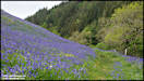
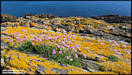
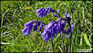
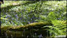
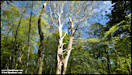
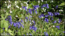
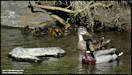
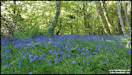
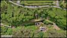
      7/5/25
On Monday afternoon
we decided to go for a walk in the Ballaugh Curragh wetlands area, driving
via Sulby Glen where I stopped for a few aerial pictures. We had
hoped that there might be a good display of Bluebells in the glen, but
maybe our timing was out or it's just a bad year, they were there but not
that impressive.
DJI Air 2S 5/5/25
7/5/25
On Monday afternoon
we decided to go for a walk in the Ballaugh Curragh wetlands area, driving
via Sulby Glen where I stopped for a few aerial pictures. We had
hoped that there might be a good display of Bluebells in the glen, but
maybe our timing was out or it's just a bad year, they were there but not
that impressive.
DJI Air 2S 5/5/25
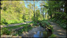
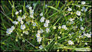
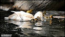
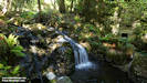
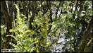
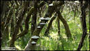
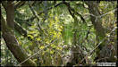
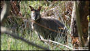
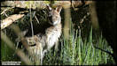
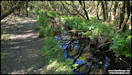
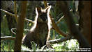
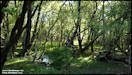
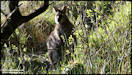
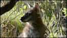
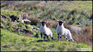
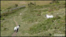
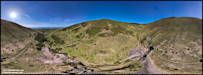
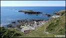
  8/5/25
Pictures from our walk
in the Ballaugh Curragh on Monday afternoon. The Curragh is a protected
conservation area consisting of natural wetlands that had once been drained
and used for agriculture. Left to revert to its natural state, there
is a network of paths thought it, sometimes on boardwalks but other times
using the tops of old 'Manx Hedges' constructed of stone and earth.
We usually see some of the wild wallabies that are concentrated in this
area, but as it was a public holiday, the paths were a bit busier than
usual (i.e. we actually saw other people!) and we thought that they might
all be hiding away, but in the end saw five of them.
Panasonic FZ82 5/5/25
8/5/25
Pictures from our walk
in the Ballaugh Curragh on Monday afternoon. The Curragh is a protected
conservation area consisting of natural wetlands that had once been drained
and used for agriculture. Left to revert to its natural state, there
is a network of paths thought it, sometimes on boardwalks but other times
using the tops of old 'Manx Hedges' constructed of stone and earth.
We usually see some of the wild wallabies that are concentrated in this
area, but as it was a public holiday, the paths were a bit busier than
usual (i.e. we actually saw other people!) and we thought that they might
all be hiding away, but in the end saw five of them.
Panasonic FZ82 5/5/25
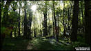
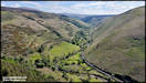
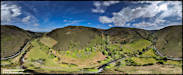
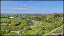
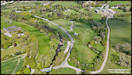
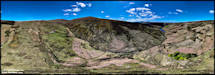
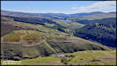
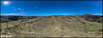
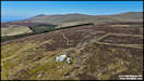
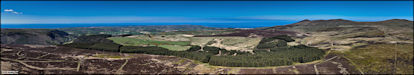
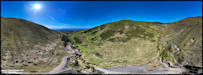
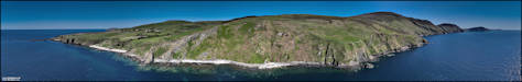
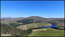
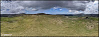
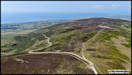
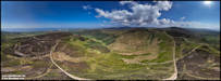
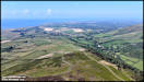
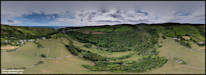
     9/5/25
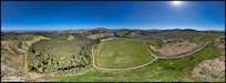
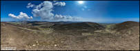
On Wednesday afternoon
I was back in Sulby Glen again, to shoot some more aerial panoramas of
this beautiful area of the island, plus some conventional shots.
The first flying location was towards the northern end of the glen, by
Mount Karrin, where an unnamed side valley leads off on the opposite side
of the glen.
DJI Mini 4 Pro 7/5/25
9/5/25
On Wednesday afternoon
I was back in Sulby Glen again, to shoot some more aerial panoramas of
this beautiful area of the island, plus some conventional shots.
The first flying location was towards the northern end of the glen, by
Mount Karrin, where an unnamed side valley leads off on the opposite side
of the glen.
DJI Mini 4 Pro 7/5/25
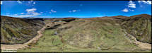
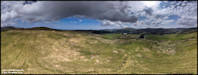
 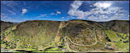 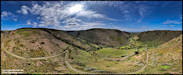  Moving on to my second
location, flying from close to the Sulby Claddagh recreational area.
Moving on to my second
location, flying from close to the Sulby Claddagh recreational area.
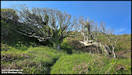
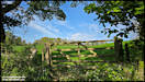
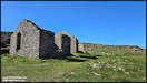
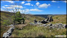
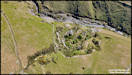
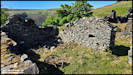
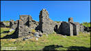
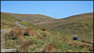
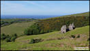
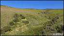
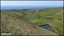
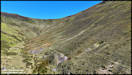
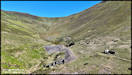
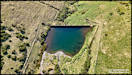
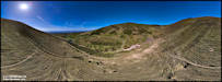
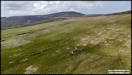
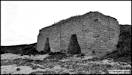
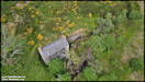
  10/5/25
I took these pictures
on a walk in the hills on Thursday afternoon, starting from Mountain Box
on the Mountain Road, then walking down to the isolated tholtan of Block
Eary, before heading up the hill to the top of Slieau Managh and back to
the car. This tholtan is probably the most isolated one on the island,
with no discernible green lane leading to it, and is mostly just a pile
of stones these days. From Ray Kelly's 'Tholtans' books it may have
been abandoned before 1900. The reservoir downstream that take its
name from the farm was constructed in the 1940s. I'm going to upload
pictures in three batches, as my computer seems to be on a go slow this
morning!
Samsung Galaxy S24 Ultra
& DJI Mini 4 Pro 8/5/25
10/5/25
I took these pictures
on a walk in the hills on Thursday afternoon, starting from Mountain Box
on the Mountain Road, then walking down to the isolated tholtan of Block
Eary, before heading up the hill to the top of Slieau Managh and back to
the car. This tholtan is probably the most isolated one on the island,
with no discernible green lane leading to it, and is mostly just a pile
of stones these days. From Ray Kelly's 'Tholtans' books it may have
been abandoned before 1900. The reservoir downstream that take its
name from the farm was constructed in the 1940s. I'm going to upload
pictures in three batches, as my computer seems to be on a go slow this
morning!
Samsung Galaxy S24 Ultra
& DJI Mini 4 Pro 8/5/25
   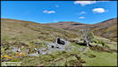 
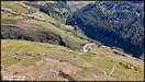
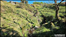
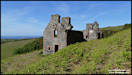
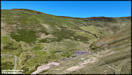
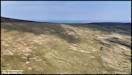
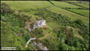
   After visiting Block
Eary tholtan, I continued onwards towards my next destination, another
tholtan, this time Slieaumanagh, named after the hill it's situated on.
Owing the the nature of the terrain, I had to climb fairly high up the
hill just to cross a gully and when I was within sight of the tholtan,
decided to take the lazy option and just fly the drone down to it, rather
than walking all the way down just to have to walk back up again!
After visiting Block
Eary tholtan, I continued onwards towards my next destination, another
tholtan, this time Slieaumanagh, named after the hill it's situated on.
Owing the the nature of the terrain, I had to climb fairly high up the
hill just to cross a gully and when I was within sight of the tholtan,
decided to take the lazy option and just fly the drone down to it, rather
than walking all the way down just to have to walk back up again!
 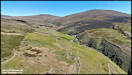 
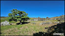
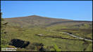
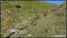
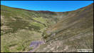
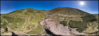
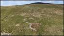
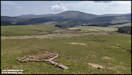
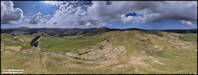
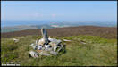
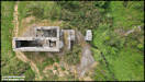
 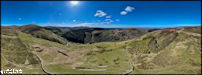 Part three of my hill
walk on Thursday was to continue onwards to the summit of Slieau Managh,
before walking down on its north side to Creg Bedn, a large outcrop
of quartz rock. In the end I didn't continue and further than the
summit, which is a bit boring in itself, but gives some great views.
Part three of my hill
walk on Thursday was to continue onwards to the summit of Slieau Managh,
before walking down on its north side to Creg Bedn, a large outcrop
of quartz rock. In the end I didn't continue and further than the
summit, which is a bit boring in itself, but gives some great views.
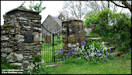
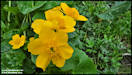
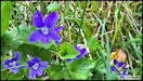
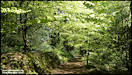
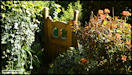
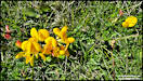
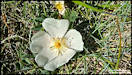
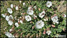
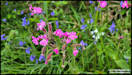
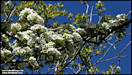
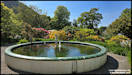
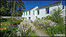
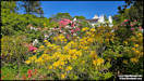
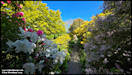
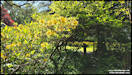
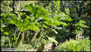
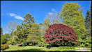
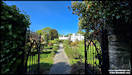
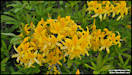
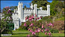
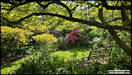
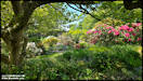
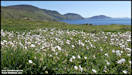
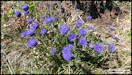
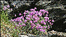
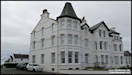
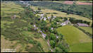
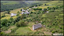
 12/5/25
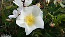
A colourful visit to
the lovely gardens at Milntown House, Ramsey on Friday afternoon.
Samsung Galaxy S24 Ultra
9/5/25
12/5/25
A colourful visit to
the lovely gardens at Milntown House, Ramsey on Friday afternoon.
Samsung Galaxy S24 Ultra
9/5/25
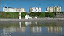
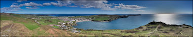
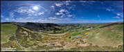
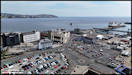
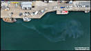
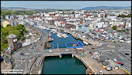
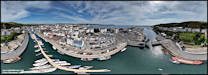
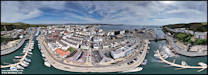
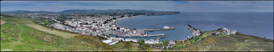
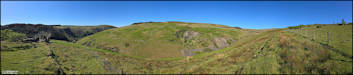
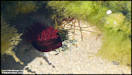
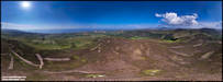
     13/5/25
A little 'side project'
that I like to work on from time to time when conditions are suitable is
taking 360 degree panoramas from various locations in and around Douglas,
as you can see so much more from the air. Sunday mornings are a good
time as it's quieter in town, this one was good as I also had light airs
and a harbour full of water!
The single shots are
a bit of a bonus, shot in between the panorama pictures.
DJI Mini 4 Pro 11/5/25
13/5/25
A little 'side project'
that I like to work on from time to time when conditions are suitable is
taking 360 degree panoramas from various locations in and around Douglas,
as you can see so much more from the air. Sunday mornings are a good
time as it's quieter in town, this one was good as I also had light airs
and a harbour full of water!
The single shots are
a bit of a bonus, shot in between the panorama pictures.
DJI Mini 4 Pro 11/5/25
    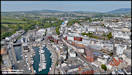
   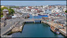 
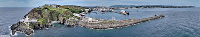
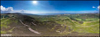
  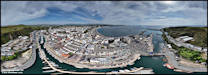 14/5/25
For my second flying
location on Sunday morning I drove up to Douglas head and shot these pictures.
DJI Mini 4 Pro
11/5/25
14/5/25
For my second flying
location on Sunday morning I drove up to Douglas head and shot these pictures.
DJI Mini 4 Pro
11/5/25
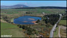
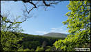
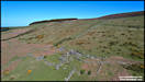
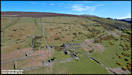
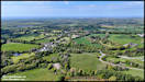
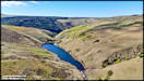
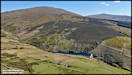
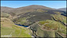
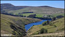
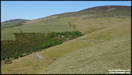
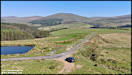
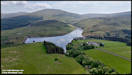
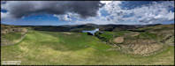
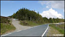
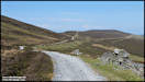
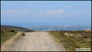
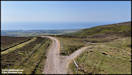
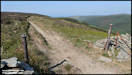
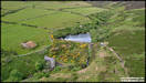
  15/5/25
On Tuesday afternoon
I went for another hill walk, this time from the Tholt y Will Road above
Sulby Reservoir, walking to the tholtan of Ballaskella, which is around
600ft above sea level and 300ft above the valley floor below in Sulby Glen.
The farm was apparently established in the 15 -1600s and abandoned in the
early 1900s.
Samsung Galaxy S24 Ultra
13/5/25
15/5/25
On Tuesday afternoon
I went for another hill walk, this time from the Tholt y Will Road above
Sulby Reservoir, walking to the tholtan of Ballaskella, which is around
600ft above sea level and 300ft above the valley floor below in Sulby Glen.
The farm was apparently established in the 15 -1600s and abandoned in the
early 1900s.
Samsung Galaxy S24 Ultra
13/5/25

  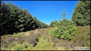   
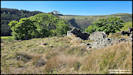  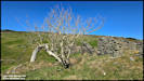 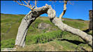 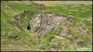
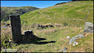   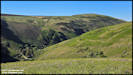  
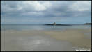
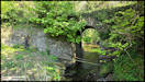
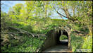
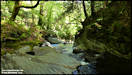
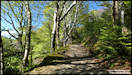
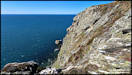
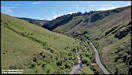
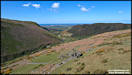
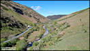
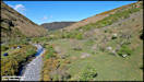
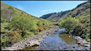
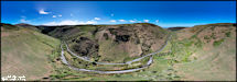
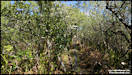
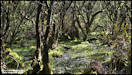
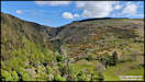
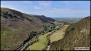
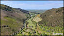
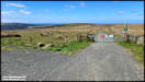
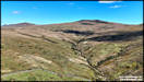
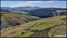
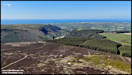
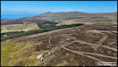
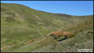
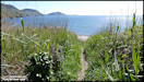
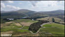
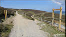
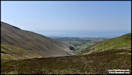
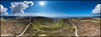
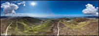
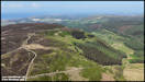
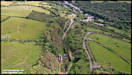
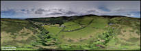
 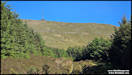    17/5/25
Thursday afternoon I
had another nice, if slightly strenuous walk in the hills, this time on
the western side of the island. Starting from the junction of the
Little London and Brandywell to Barregarrow Roads, then walking initially
to the old Glion Kiark slate quarry office building. The next bit
was the hardest, continuing north and ending up in the 'U' shaped glacial
valley where the old Kirkmichael Mine was. It's quite up and down
for the first segment and you have to cross a few secondary valleys.
Now is a good time to do it as the bracken is starting to grow, in a couple
of months it will be chest height making it very difficult to find the
paths.
Panasonic TZ95 &
DJI Mini 4 Pro 15/5/25
17/5/25
Thursday afternoon I
had another nice, if slightly strenuous walk in the hills, this time on
the western side of the island. Starting from the junction of the
Little London and Brandywell to Barregarrow Roads, then walking initially
to the old Glion Kiark slate quarry office building. The next bit
was the hardest, continuing north and ending up in the 'U' shaped glacial
valley where the old Kirkmichael Mine was. It's quite up and down
for the first segment and you have to cross a few secondary valleys.
Now is a good time to do it as the bracken is starting to grow, in a couple
of months it will be chest height making it very difficult to find the
paths.
Panasonic TZ95 &
DJI Mini 4 Pro 15/5/25
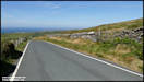     
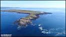
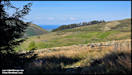
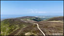
    18/5/25
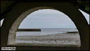
The settled, warm and
sunny weather is continuing, and on Friday afternoon I took a trip 'out
west' to the lovely location of Niarbyl. I always park at the top,
by the currently empty cafe and looking down from there I could see quite
a few cars parked at the back of the beach, which can spoil the photography
options. So instead of walking down the road I took the clifftop
path along to Traie Vane, the White Beach, which apart from one chap fishing
from a kayak, was totally deserted.
Panasonic TZ95 &
DJI Mini 4 Pro 16/5/25
18/5/25
The settled, warm and
sunny weather is continuing, and on Friday afternoon I took a trip 'out
west' to the lovely location of Niarbyl. I always park at the top,
by the currently empty cafe and looking down from there I could see quite
a few cars parked at the back of the beach, which can spoil the photography
options. So instead of walking down the road I took the clifftop
path along to Traie Vane, the White Beach, which apart from one chap fishing
from a kayak, was totally deserted.
Panasonic TZ95 &
DJI Mini 4 Pro 16/5/25
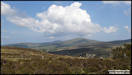
    19/5/25
We currently have a
friend staying with us and on Saturday afternoon took her out on a sightseeing
trip heading to the north. In the morning I had done a firmware upgrade
on the mini drone so programmed in a stop at a scenic area of Druidale
for them to enjoy the view and me to carry out a check test flight!
DJI Mini 4 Pro
17/5/25
19/5/25
We currently have a
friend staying with us and on Saturday afternoon took her out on a sightseeing
trip heading to the north. In the morning I had done a firmware upgrade
on the mini drone so programmed in a stop at a scenic area of Druidale
for them to enjoy the view and me to carry out a check test flight!
DJI Mini 4 Pro
17/5/25
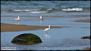
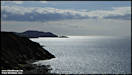
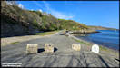
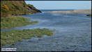
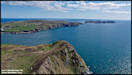
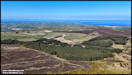
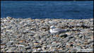
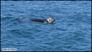
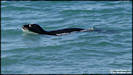
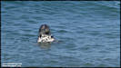
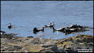
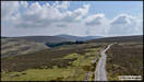
  Continuing on our 'scenic
drive', we ended up at the Point of Ayre where I took these pictures.
Large areas of the shingle are currently cordoned off the protect the seabirds
that are nesting there and visitors are asked to try and avoid disturbing
them and the seals that haul out here.
Panasonic TZ95 17/5/25
Continuing on our 'scenic
drive', we ended up at the Point of Ayre where I took these pictures.
Large areas of the shingle are currently cordoned off the protect the seabirds
that are nesting there and visitors are asked to try and avoid disturbing
them and the seals that haul out here.
Panasonic TZ95 17/5/25
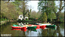
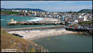
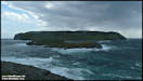
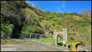
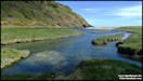
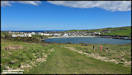
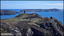
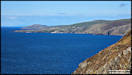
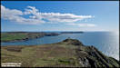
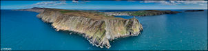
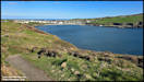
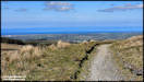
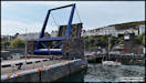
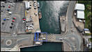
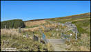
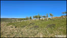
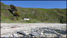
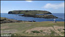
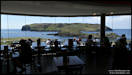
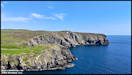
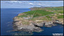
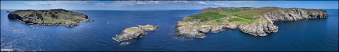
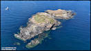
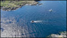
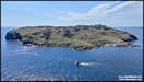
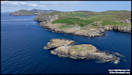
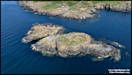
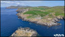
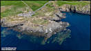
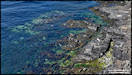
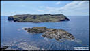
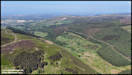
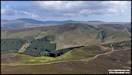
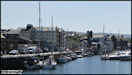
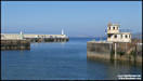
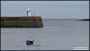
  21/5/25
On Monday we took our
visiting friend to The Sound for lunch and I shot a few pictures there,
from ground and air.
Panasonic TZ95 &
DJI Mini 4 Pro 19/5/25
21/5/25
On Monday we took our
visiting friend to The Sound for lunch and I shot a few pictures there,
from ground and air.
Panasonic TZ95 &
DJI Mini 4 Pro 19/5/25
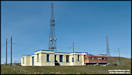
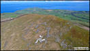
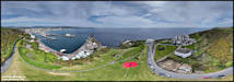
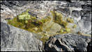
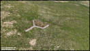
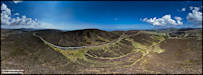
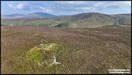
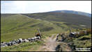
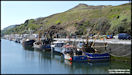
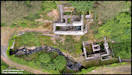
  22/5/25
I had quite a busy day,
photography wise, on Tuesday. In the morning I headed out to
investigate a possible old Triskelion (3 Legs) on a hillside above Druidale.
It was mentioned to me by Don Brown of the 'Footpaths of the Isle of Man'
Facebook group, asking if I had any aerial photos of it. I'd never
even heard of it before but checking Google Earth I could see what he was
talking about and it was also marked on the Outdoor Leisure map, although
just as some short lines. Having looked at the aerial shots I took
I still wasn't 100% convinced, there were certainly 3 legs to it, but only
one had the lower leg section and I started to wonder if in fact it was
some kind of sheep management structure which are found at various locations
on these hills. When I was working on the pictures to show here I
looked at the 1870 Ordnance Survey Map, not expecting to find anything,
but there it was, marked as a 'Sheepfold'. So there we have it, a
sheepfold but maybe deliberately arranged as a triskelion, who knows?
DJI Mini 4 Pro 20/5/25
22/5/25
I had quite a busy day,
photography wise, on Tuesday. In the morning I headed out to
investigate a possible old Triskelion (3 Legs) on a hillside above Druidale.
It was mentioned to me by Don Brown of the 'Footpaths of the Isle of Man'
Facebook group, asking if I had any aerial photos of it. I'd never
even heard of it before but checking Google Earth I could see what he was
talking about and it was also marked on the Outdoor Leisure map, although
just as some short lines. Having looked at the aerial shots I took
I still wasn't 100% convinced, there were certainly 3 legs to it, but only
one had the lower leg section and I started to wonder if in fact it was
some kind of sheep management structure which are found at various locations
on these hills. When I was working on the pictures to show here I
looked at the 1870 Ordnance Survey Map, not expecting to find anything,
but there it was, marked as a 'Sheepfold'. So there we have it, a
sheepfold but maybe deliberately arranged as a triskelion, who knows?
DJI Mini 4 Pro 20/5/25
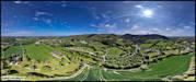
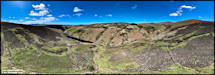
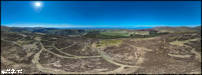
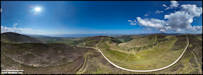
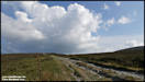
   I took advantage of
having the drone up to shoot a few panoramas in this beautiful and remote
area of the island!
Don't forget to click
the larger images for the interactive versions.
I took advantage of
having the drone up to shoot a few panoramas in this beautiful and remote
area of the island!
Don't forget to click
the larger images for the interactive versions.
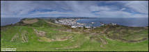
    24/5/25
I'd said that Tuesday
was a busy day for me and in the afternoon I set out to walk to another
possible hillside triskelion site, one that I had discovered many years
ago, on the west facing slopes of Slieau Curn in the hills above Ballaugh.
I parked the car in the handy walkers car park close to Brandywell Cottage
and then walked along the track that follows the line of the hills towards
Ballaugh. I took the mini drone with the specific idea of shooting a series
of 360 degree panoramas along the route.
Panasonic TZ95 &
DJI Mini 4 Pro 20/5/25
24/5/25
I'd said that Tuesday
was a busy day for me and in the afternoon I set out to walk to another
possible hillside triskelion site, one that I had discovered many years
ago, on the west facing slopes of Slieau Curn in the hills above Ballaugh.
I parked the car in the handy walkers car park close to Brandywell Cottage
and then walked along the track that follows the line of the hills towards
Ballaugh. I took the mini drone with the specific idea of shooting a series
of 360 degree panoramas along the route.
Panasonic TZ95 &
DJI Mini 4 Pro 20/5/25

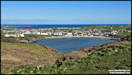
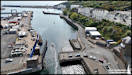
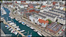
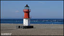
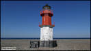
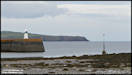
   25/5/25
On Wednesday we took
our visiting friend to Peel for lunch, before she had to catch her flight
back to Edinburgh, and I took a few pics.
Panasonic TZ95 21/5/25
25/5/25
On Wednesday we took
our visiting friend to Peel for lunch, before she had to catch her flight
back to Edinburgh, and I took a few pics.
Panasonic TZ95 21/5/25
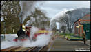
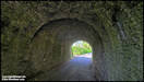
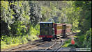
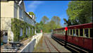
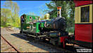
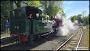
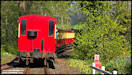
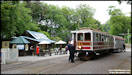
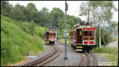
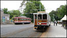
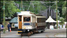
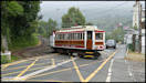
     I had changed some settings
on the TZ95 and wanted to try them out, so these tram pictures were taken
at Laxey yesterday afternoon.
Panasonic TZ95 24/5/25
I had changed some settings
on the TZ95 and wanted to try them out, so these tram pictures were taken
at Laxey yesterday afternoon.
Panasonic TZ95 24/5/25
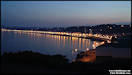
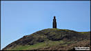
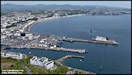
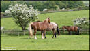
    27/5/25
I just came across these
pictures this morning, although I actually took them over a week ago, when
we took our visiting friend to the Home of Rest for Old Horses,
followed by a quick
visit to Douglas Head and the Marine Drive.
Panasonic TZ95
18/5/25
27/5/25
I just came across these
pictures this morning, although I actually took them over a week ago, when
we took our visiting friend to the Home of Rest for Old Horses,
followed by a quick
visit to Douglas Head and the Marine Drive.
Panasonic TZ95
18/5/25
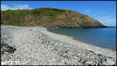
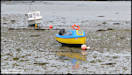
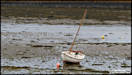
      28/5/25
My initial photographic
plans for yesterday afternoon didn't work out quite as expected due to
the weather, as drone flying and rain don't mix well! I ended up
at Derbyhaven, where I wouldn't normally plan to take pictures unless the
tide was fairly high, but sometimes it's interesting to accept a bit of
a challenge, so here are the results!
Panasonic TZ95 27/5/25
28/5/25
My initial photographic
plans for yesterday afternoon didn't work out quite as expected due to
the weather, as drone flying and rain don't mix well! I ended up
at Derbyhaven, where I wouldn't normally plan to take pictures unless the
tide was fairly high, but sometimes it's interesting to accept a bit of
a challenge, so here are the results!
Panasonic TZ95 27/5/25
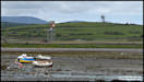    
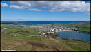
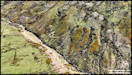
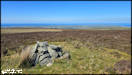
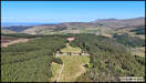
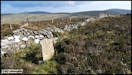
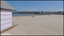
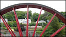
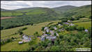
    29/5/25
After several weeks
of fine and sunny weather, we now seem to have entered a period of unsettled,
wet and windy conditions. However, yesterday was bright and mainly
sunny, and with a light wind I decided that I should take advantage to
take some aerial pictures. My chosen location was the little hamlet
of Agneash, up in the hills above Laxey, looking at the village and some
of the remains of the once extensive mining activity around here, including
the world famous Laxey Wheel.
Many thanks to Andrew
Scarffe's excellent 'The Great Laxey Mine' book for identifying the various
old structures featured.
DJI Air 2S 28/5/25
29/5/25
After several weeks
of fine and sunny weather, we now seem to have entered a period of unsettled,
wet and windy conditions. However, yesterday was bright and mainly
sunny, and with a light wind I decided that I should take advantage to
take some aerial pictures. My chosen location was the little hamlet
of Agneash, up in the hills above Laxey, looking at the village and some
of the remains of the once extensive mining activity around here, including
the world famous Laxey Wheel.
Many thanks to Andrew
Scarffe's excellent 'The Great Laxey Mine' book for identifying the various
old structures featured.
DJI Air 2S 28/5/25
    These 360 degree panoramas
were all shot around the Agneash area.
These 360 degree panoramas
were all shot around the Agneash area.
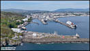
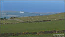
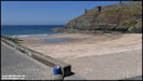
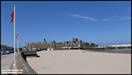
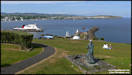
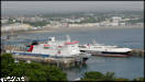
   31/5/25
One last picture for
this month, the Steam Packet's 'Ben my Chree' and 'Manannan' in Douglas
habour in between their busy schedule during the TT Races. The third
current ship in the fleet, 'Manxman' was across the water in Heysham, probably
coming back this afternoon with a full load of biker and bikes.
Panasonic TZ95 31/5/25
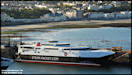
31/5/25
One last picture for
this month, the Steam Packet's 'Ben my Chree' and 'Manannan' in Douglas
habour in between their busy schedule during the TT Races. The third
current ship in the fleet, 'Manxman' was across the water in Heysham, probably
coming back this afternoon with a full load of biker and bikes.
Panasonic TZ95 31/5/25
|