Twenty Five Years
of Island Images - March 2000 - 2024
|
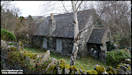
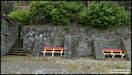
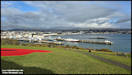
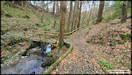
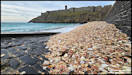
3/3/25
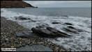
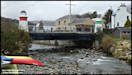
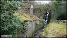
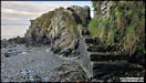
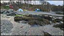
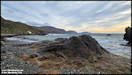
A selection of pictures
taken on a rather dull and overcast Sunday afternoon in Laxey.
Panasonic FZ82 2/3/25
 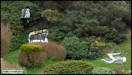   
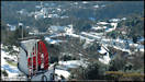
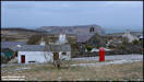
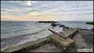
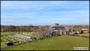
 4/3/25
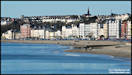
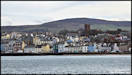
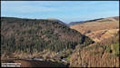
Yesterday morning I
had an early appointment in Douglas and after leaving I headed up to Douglas
Head to take the view over the town in the morning sunshine.
Samsung Galaxy S24 Ultra
3/3/25
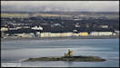
4/3/25
Yesterday morning I
had an early appointment in Douglas and after leaving I headed up to Douglas
Head to take the view over the town in the morning sunshine.
Samsung Galaxy S24 Ultra
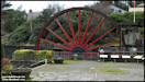
3/3/25
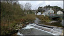
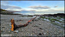
     I went via the Groudle
Road on the way home and was lucky enough to catch one of the Manx Electric
Railway cars out on the road on a 'drying out' run after winter lay-up.
Car No 7 was delivered to the line in 1894 for the extension of the line
from Groudle to Laxey. Public services commence later in the month.
I went via the Groudle
Road on the way home and was lucky enough to catch one of the Manx Electric
Railway cars out on the road on a 'drying out' run after winter lay-up.
Car No 7 was delivered to the line in 1894 for the extension of the line
from Groudle to Laxey. Public services commence later in the month.
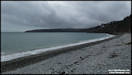
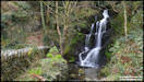
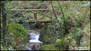
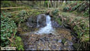
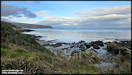
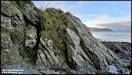
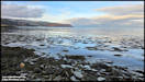
 5/3/25
A visit to Garwick Glen
and beach on Monday afternoon. Unfortunately the glen is currently
totally blocked by fallen trees just below the Wishing Stone, so I had
to retrace my steps and walk down the path from the Clay Head road instead
of walking through the glen.
Samsung Galaxy S24 Ultra
3/3/25
5/3/25
A visit to Garwick Glen
and beach on Monday afternoon. Unfortunately the glen is currently
totally blocked by fallen trees just below the Wishing Stone, so I had
to retrace my steps and walk down the path from the Clay Head road instead
of walking through the glen.
Samsung Galaxy S24 Ultra
3/3/25
    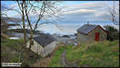
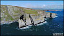
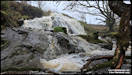
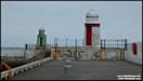
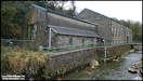
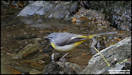
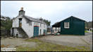
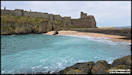
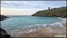
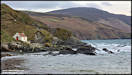
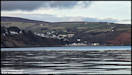     6/3/25
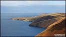
A few pictures taken
on a trip out on Tuesday afternoon, at Peel and Niarbyl.
Samsung Galaxy S24 Ultra
4/3/25
6/3/25
A few pictures taken
on a trip out on Tuesday afternoon, at Peel and Niarbyl.
Samsung Galaxy S24 Ultra
4/3/25
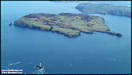
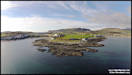
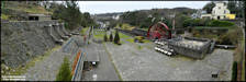
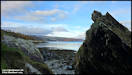
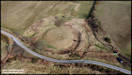
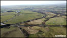
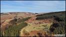
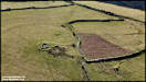
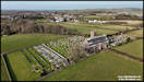
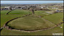
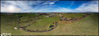
     7/3/25
These aerial pictures
were taken yesterday morning on what was really just a test flight with
one of my older drones, the DJI Mini 2. I've actually flown more
hours using this one than any other, with over 100 hours in the air logged.
However, back in November 2024 I effectively replaced it with the much
newer Mini 4 Pro and It hadn't flown since then. The site I chose
is an interesting historical one, the Santon Broogh. Although only
a few miles outside Douglas, it has never been archeologically investigated
so little is known about it. It comprises a central flat topped mound,
surrounded by a ditch with two banks outside that on the south and east
side. On the other side the ground is marshy. One theory is that
it was a Medieval Motte, with the ditches and banks as defences on the
side away from the marshy ground. Other suggestions are a possible
burial site or an Iron Age ring fort, such as those found across the water
in Ireland.
DJI Mini 2 6/3/25
7/3/25
These aerial pictures
were taken yesterday morning on what was really just a test flight with
one of my older drones, the DJI Mini 2. I've actually flown more
hours using this one than any other, with over 100 hours in the air logged.
However, back in November 2024 I effectively replaced it with the much
newer Mini 4 Pro and It hadn't flown since then. The site I chose
is an interesting historical one, the Santon Broogh. Although only
a few miles outside Douglas, it has never been archeologically investigated
so little is known about it. It comprises a central flat topped mound,
surrounded by a ditch with two banks outside that on the south and east
side. On the other side the ground is marshy. One theory is that
it was a Medieval Motte, with the ditches and banks as defences on the
side away from the marshy ground. Other suggestions are a possible
burial site or an Iron Age ring fort, such as those found across the water
in Ireland.
DJI Mini 2 6/3/25
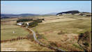   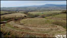 
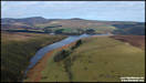
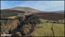
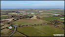
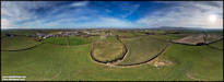
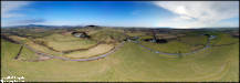 9/3/25
Yesterday afternoon
was fine and sunny and I decided to take the mini drone out for some aerial
photography, shooting mainly 360 degree panoramas. The initial plan
was to shoot at three different locations Sulby Glen, but in the event
I had to alter my plans after the breeze was stronger than expected at
the first location.
DJI Mini 4 Pro 8/3/25
9/3/25
Yesterday afternoon
was fine and sunny and I decided to take the mini drone out for some aerial
photography, shooting mainly 360 degree panoramas. The initial plan
was to shoot at three different locations Sulby Glen, but in the event
I had to alter my plans after the breeze was stronger than expected at
the first location.
DJI Mini 4 Pro 8/3/25
   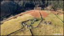 
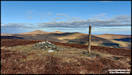
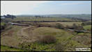
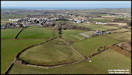
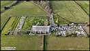
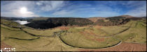 After checking out my
other planned Sulby Glen sites I deciding that the the breeze was being
funnelled down the glen, increasing its strength. I decided to look
for an alternative location for a second flight and after considering a
couple, settled on the area of Andreas Church in the north of the island.
The church was constructed in 1802 with a separate tower being added in
1869 and replaced an older church just to the north of the present one.
The tower was originally much taller, but was reduced in height during
WW2 as it was considered to be a danger to the fighter aircraft based at
nearby RAF Andreas. The plan was to rebuilt it after the war, but that
never happened.
DJI Mini 4 Pro 8/3/25
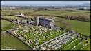
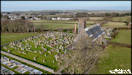
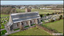
After checking out my
other planned Sulby Glen sites I deciding that the the breeze was being
funnelled down the glen, increasing its strength. I decided to look
for an alternative location for a second flight and after considering a
couple, settled on the area of Andreas Church in the north of the island.
The church was constructed in 1802 with a separate tower being added in
1869 and replaced an older church just to the north of the present one.
The tower was originally much taller, but was reduced in height during
WW2 as it was considered to be a danger to the fighter aircraft based at
nearby RAF Andreas. The plan was to rebuilt it after the war, but that
never happened.
DJI Mini 4 Pro 8/3/25
10/3/25
That's it for a few
weeks I'm afraid, Island Images is taking a break! Hope to see you
again next month.
I have uploaded the
'25 Years of April in Island Images'
section though!
|