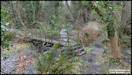
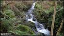
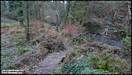
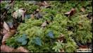
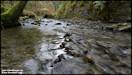
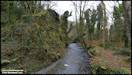
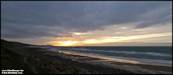
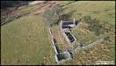
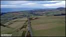
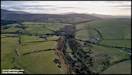
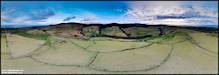
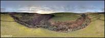
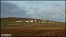
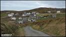
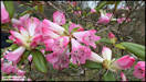
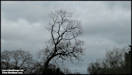
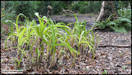
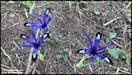
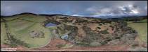
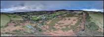
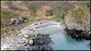
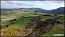
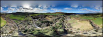
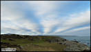
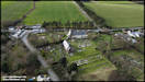
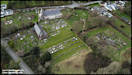
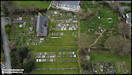
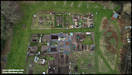
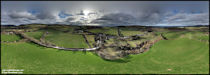
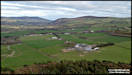
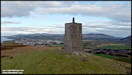
3/2/23
I took these pictures
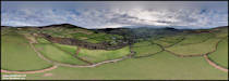
on a visit yesterday afternoon to the Cooildarry Nature Reserve, just south
of Kirkmichael. I hadn't been into the reserve for many years so
didn't remember it well. There are several paths that you can take
but they don't link up, so I had to do fair bit of backtracking to where
they join. I did wonder if Manx Wildlife Trust, who own the reserve,
were hoping to acquire more of the valley eventually so they could link
the paths up. There is an informative sign at the reserve entrance,
that rather mysteriously tells you that it is open for 364 days per year,
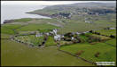
but doesn't mention which day it might be closed!
Panasonic FZ82 2/2/23
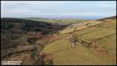
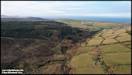
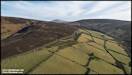
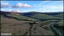
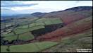
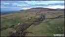
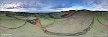
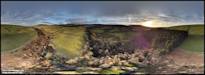
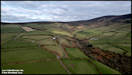
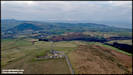
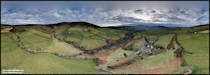
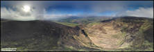
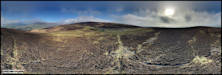
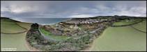
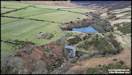
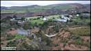
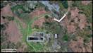
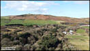
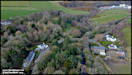
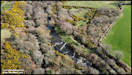
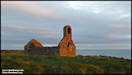
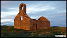
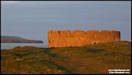
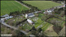
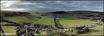
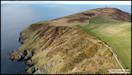
 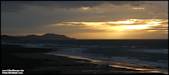  6/2/23
Yesterday morning was
sunny and with (generally) light winds, so I took the opportunity to carry
out some aerial photography. The location I chose was the upper reaches
of the Rhenass River, close to where the Beinn-y-Phott road starts to dip
down towards Barregarrow after passing Brandywell Cottage. The is
an old tholtan, Cronkdoo, down on the hillside there that I thought would
be interesting to photograph.
DJI Air 2S 5/2/23
6/2/23
Yesterday morning was
sunny and with (generally) light winds, so I took the opportunity to carry
out some aerial photography. The location I chose was the upper reaches
of the Rhenass River, close to where the Beinn-y-Phott road starts to dip
down towards Barregarrow after passing Brandywell Cottage. The is
an old tholtan, Cronkdoo, down on the hillside there that I thought would
be interesting to photograph.
DJI Air 2S 5/2/23
  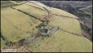  
  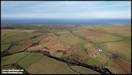 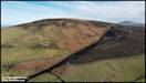 
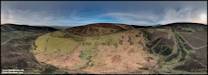 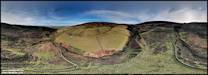 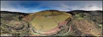
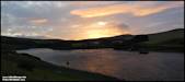
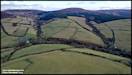
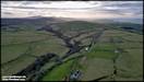
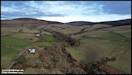
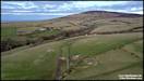
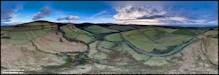
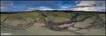
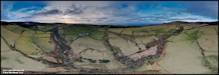
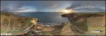
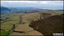
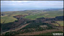
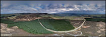
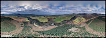
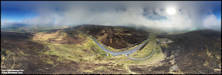
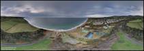
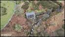
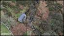
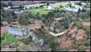
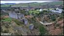
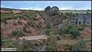
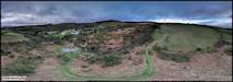
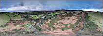
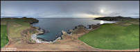
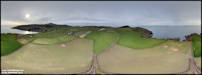
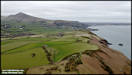
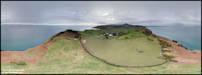
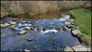
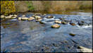
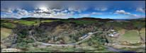
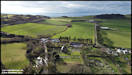
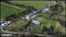
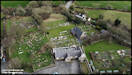
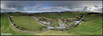
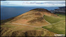
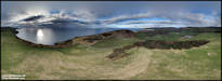
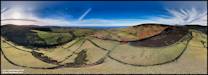 7/2/23
With flying conditions
still good yesterday, I decided in the afternoon to continue looking at
the Rhenass Valley from the air, planning to work my way down from just
north of Little London to where the Rhenass and Blaber Rivers join at Glen
Helen before they continue to the sea at Peel as the River Neb. I
was mainly planning on shooting 360 panoramas, but as always shot some
conventional scenes as well.
DJI Air 2S &
DJI Mini 2 6/2/23
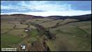
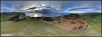
7/2/23
With flying conditions
still good yesterday, I decided in the afternoon to continue looking at
the Rhenass Valley from the air, planning to work my way down from just
north of Little London to where the Rhenass and Blaber Rivers join at Glen
Helen before they continue to the sea at Peel as the River Neb. I
was mainly planning on shooting 360 panoramas, but as always shot some
conventional scenes as well.
DJI Air 2S &
DJI Mini 2 6/2/23
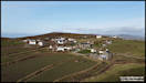
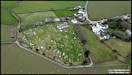
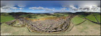
  10/2/23
I've recently been
doing a lot of work on the presentation of the 360 degree panoramas in
their own section, now including a separate Locations Index for them.
One thing that came to light from that was that I didn't seem to have any
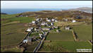
specific one of Cregneash, so yesterday afternoon I thought that I would
try and remedy that. The weather was sunny but rather on the breezy
side for the Mini 2 drone, so it ended up being a rather short flight!
DJI Mini 2 9/2/23
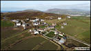
10/2/23
I've recently been
doing a lot of work on the presentation of the 360 degree panoramas in
their own section, now including a separate Locations Index for them.
One thing that came to light from that was that I didn't seem to have any
specific one of Cregneash, so yesterday afternoon I thought that I would
try and remedy that. The weather was sunny but rather on the breezy
side for the Mini 2 drone, so it ended up being a rather short flight!
DJI Mini 2 9/2/23
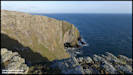
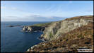
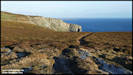
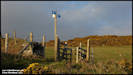
 After stowing the drone
back away in my rucksack, I continued with my planned walk, heading for
Black Head and Spanish Head.
Panasonic FZ82 9/2/23
After stowing the drone
back away in my rucksack, I continued with my planned walk, heading for
Black Head and Spanish Head.
Panasonic FZ82 9/2/23
 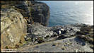   
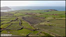
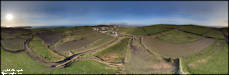
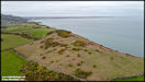
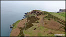
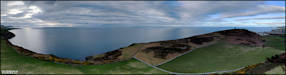
     When I reached The Chasms,
the wind seemed to have died down enough to attempt another drone flight
for some aerial pictures. I was still a bit breezy up aloft, so again
I kept the flight time fairly short, but did manage a couple of 360 degree
panoramas.
DJI Mini 2 9/2/23
When I reached The Chasms,
the wind seemed to have died down enough to attempt another drone flight
for some aerial pictures. I was still a bit breezy up aloft, so again
I kept the flight time fairly short, but did manage a couple of 360 degree
panoramas.
DJI Mini 2 9/2/23
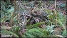
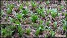
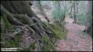
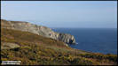
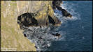
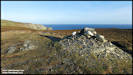
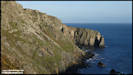
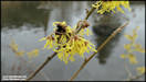
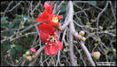
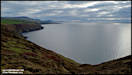
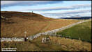
  A few more pictures
that I shot from ground level on the walk from The Chasms to Cregneash.
A few more pictures
that I shot from ground level on the walk from The Chasms to Cregneash.
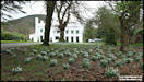
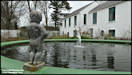
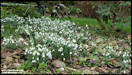
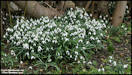
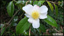
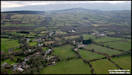
    12/2/23
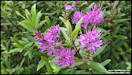
A visit to Milntown
House to see the Snowdrops and have lunch in the excellent cafe there.
After lunch we had a stroll around the gardens.
Panasonic TZ200 10/2/23
12/2/23
A visit to Milntown
House to see the Snowdrops and have lunch in the excellent cafe there.
After lunch we had a stroll around the gardens.
Panasonic TZ200 10/2/23
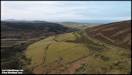
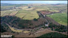
    13/2/23
A little trip out
yesterday afternoon for some aerial photography in the hills above Greeba.
I had hoped for some late afternoon sunshine as gaps seemed to be appearing
in the clouds, but the opposite happened in the end and they closed up,
making for some rather dull lighting in the end. The was also quite
a bit of smoke drifting down the central valley, it looked like from a
fire somewhere in the Patrick area, its amazing how far smoke can drift.
DJI Air 2S 12/2/23
13/2/23
A little trip out
yesterday afternoon for some aerial photography in the hills above Greeba.
I had hoped for some late afternoon sunshine as gaps seemed to be appearing
in the clouds, but the opposite happened in the end and they closed up,
making for some rather dull lighting in the end. The was also quite
a bit of smoke drifting down the central valley, it looked like from a
fire somewhere in the Patrick area, its amazing how far smoke can drift.
DJI Air 2S 12/2/23
    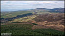
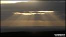
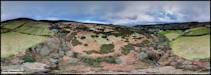
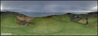
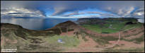
 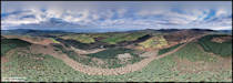  14/2/23
Yesterday I did a
test flight to check out a possibly suspect battery on my Mini 2.
There was a chance that I might need to do a quick landing so I chose the
moorland near Keppel Gate, where there is a lot of heather around for a
soft landing! The flight went without any problem in the end and
I shot these 360 panoramas while I was doing it. Weather conditions
were quite interesting, with a moderate breeze but low level clouds drifting
over the surrounding hills. PtGui had a few issues stitching some
of the images together so there's been a little cloning work done on the
final products! Click the larger images for the interactive versions.
DJI Mini 2 13/2/23
14/2/23
Yesterday I did a
test flight to check out a possibly suspect battery on my Mini 2.
There was a chance that I might need to do a quick landing so I chose the
moorland near Keppel Gate, where there is a lot of heather around for a
soft landing! The flight went without any problem in the end and
I shot these 360 panoramas while I was doing it. Weather conditions
were quite interesting, with a moderate breeze but low level clouds drifting
over the surrounding hills. PtGui had a few issues stitching some
of the images together so there's been a little cloning work done on the
final products! Click the larger images for the interactive versions.
DJI Mini 2 13/2/23
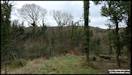
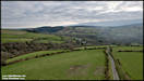
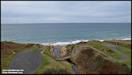
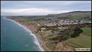
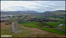
   16/2/23
A few aerial pictures
I took yesterday afternoon in the Glen Wyllin area by Kirkmichael.
Again the weather turned out a bit on the dull side!
DJI Air 2S 15/2/23
16/2/23
A few aerial pictures
I took yesterday afternoon in the Glen Wyllin area by Kirkmichael.
Again the weather turned out a bit on the dull side!
DJI Air 2S 15/2/23
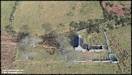
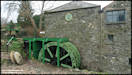
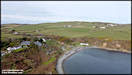
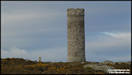
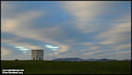
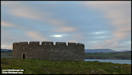
  21/2/23
Old and new around
Agneash yesterday afternoon! Some aerial pictures of the old winding
house for the North Shaft of the Great Laxey Mine and then the very new
footbridge down by the remains of the Dumbell's Shaft water wheel case,
closer to the village.
Historical information
from Andrew Scarffe brilliant 'The Great Laxey Mine' book
DJI Air 2S 20/2/23
21/2/23
Old and new around
Agneash yesterday afternoon! Some aerial pictures of the old winding
house for the North Shaft of the Great Laxey Mine and then the very new
footbridge down by the remains of the Dumbell's Shaft water wheel case,
closer to the village.
Historical information
from Andrew Scarffe brilliant 'The Great Laxey Mine' book
DJI Air 2S 20/2/23
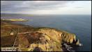
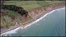
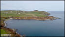
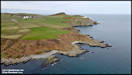
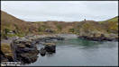
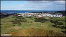
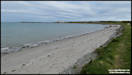
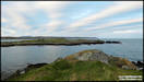
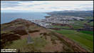
   24/2/23
A little trip out
yesterday afternoon to the north east coast of the island, at Port Mooar
and Maughold.
DJI Mini 2 23/2/23
24/2/23
A little trip out
yesterday afternoon to the north east coast of the island, at Port Mooar
and Maughold.
DJI Mini 2 23/2/23
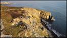
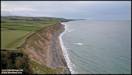
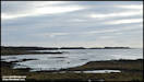
  After the flight at
Port Moor, I followed the coastal footpath towards Maughold village.
I wasn't sure of its status as it had been officially closed recently due
to land slippage and I had noticed a 'Footpath Closed' at the top of the
road down to the beach. However, there was nothing actually at the
start of the footpath and it was certainly passable with a little care
in places along the section that I wanted to walk. Not sure how it
is climbing up the cliff though.
After the flight at
Port Moor, I followed the coastal footpath towards Maughold village.
I wasn't sure of its status as it had been officially closed recently due
to land slippage and I had noticed a 'Footpath Closed' at the top of the
road down to the beach. However, there was nothing actually at the
start of the footpath and it was certainly passable with a little care
in places along the section that I wanted to walk. Not sure how it
is climbing up the cliff though.
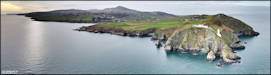
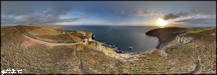
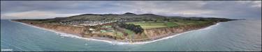
  Moving on to my third
and final flying location of the day, near to Maughold village.
Moving on to my third
and final flying location of the day, near to Maughold village.
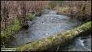
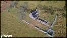
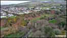
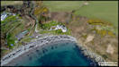
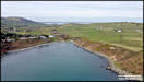
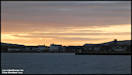
  26/2/23
When I took these
pictures we were really just out for a walk with a friend, starting form
Peel and walking along the Rive Neb to The Raggat, but I had the little
drone with me and took the opportunity for a flight for some aerial views.
DJI Mini 2 25/2/23
26/2/23
When I took these
pictures we were really just out for a walk with a friend, starting form
Peel and walking along the Rive Neb to The Raggat, but I had the little
drone with me and took the opportunity for a flight for some aerial views.
DJI Mini 2 25/2/23
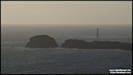
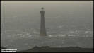
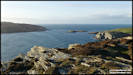
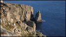
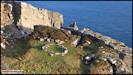
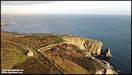
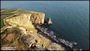
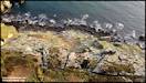
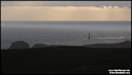
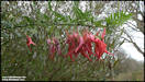
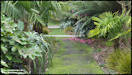
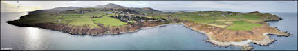
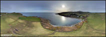
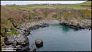
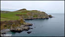
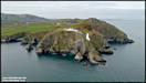
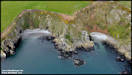
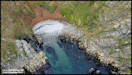
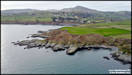
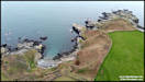
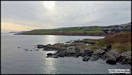
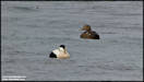
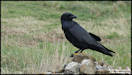
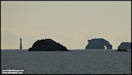
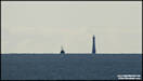
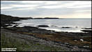
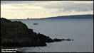
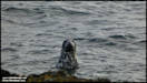
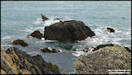
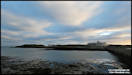
   27/2/23
Yesterday afternoon
we took a walk around the Langness peninsula, starting and finishing at
Fort Island. It's just over five miles the way we do it and took
us just under three hours, but that does include a lot of stops for photography
and looking at the wildlife.
Panasonic FZ82
26/2/23
27/2/23
Yesterday afternoon
we took a walk around the Langness peninsula, starting and finishing at
Fort Island. It's just over five miles the way we do it and took
us just under three hours, but that does include a lot of stops for photography
and looking at the wildlife.
Panasonic FZ82
26/2/23
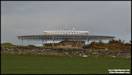
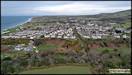
     28/2/23
I've been trying
to carry our some aerial photography of part of the island that I've not
covered before and yesterday afternoon visited the little village of Patrick,
to the south of Peel. Nowadays just a little community centred around
the church, during World War 1 it became host to a huge internment camp
for 'enemy aliens' situated on Knockaloe Farm. The camp eventually
housed around 24,000 detainees and was served by a branch railway line
climbing up from The Raggatt, which was used for delivering the large quantity
of supplies needed for such a large camp. There is a visitor centre
telling the story of the camp in the village, although it is currently
closed (should be opening in April), but also has a website full of information
- Knockaloe.im
The church is (to
me) somewhat confusingly known as Kirk Patrick (Holy Trinity), not St Patrick's.
DJI Mini 2 27/2/23
28/2/23
I've been trying
to carry our some aerial photography of part of the island that I've not
covered before and yesterday afternoon visited the little village of Patrick,
to the south of Peel. Nowadays just a little community centred around
the church, during World War 1 it became host to a huge internment camp
for 'enemy aliens' situated on Knockaloe Farm. The camp eventually
housed around 24,000 detainees and was served by a branch railway line
climbing up from The Raggatt, which was used for delivering the large quantity
of supplies needed for such a large camp. There is a visitor centre
telling the story of the camp in the village, although it is currently
closed (should be opening in April), but also has a website full of information
- Knockaloe.im
The church is (to
me) somewhat confusingly known as Kirk Patrick (Holy Trinity), not St Patrick's.
DJI Mini 2 27/2/23
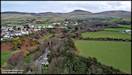
  1/3/23
After taking the aerial
pictures at Patrick, I drove down the road to The Raggatt for a walk up
to Peel Hill. As I found out the following day I could have just
walked from Patrick through Knockaloe Farm, but as the footpath is just
a 'Permissive Path' and not a Right of Way, it isn't marked on the Outdoor
Leisure map. I was planning some more aerial shots of Knockaloe from
the sea side, although the sun mostly hid behind cloud while I was there.
DJI Mini 2 27/2/23
1/3/23
After taking the aerial
pictures at Patrick, I drove down the road to The Raggatt for a walk up
to Peel Hill. As I found out the following day I could have just
walked from Patrick through Knockaloe Farm, but as the footpath is just
a 'Permissive Path' and not a Right of Way, it isn't marked on the Outdoor
Leisure map. I was planning some more aerial shots of Knockaloe from
the sea side, although the sun mostly hid behind cloud while I was there.
DJI Mini 2 27/2/23
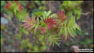
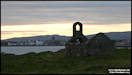
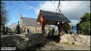
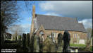
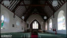
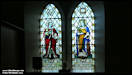
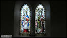
   As promised, some ground
level photography at Kirk Patrick.
Panasonic TZ200 28/2/23
As promised, some ground
level photography at Kirk Patrick.
Panasonic TZ200 28/2/23
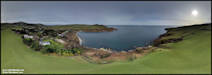
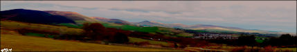
     Last February picture.
This started off as six hand held shots for stitching into a panorama of
'The Plains of Heaven'. I wasn't that impressed with the end result
so set to work in it in Corel Painter Essentials 4 and Paint Shop Pro.
This is the end result!
Last February picture.
This started off as six hand held shots for stitching into a panorama of
'The Plains of Heaven'. I wasn't that impressed with the end result
so set to work in it in Corel Painter Essentials 4 and Paint Shop Pro.
This is the end result!
|