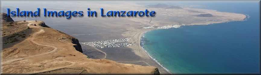
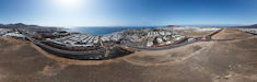
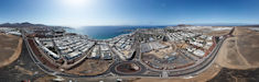
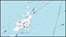
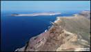
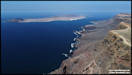
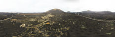
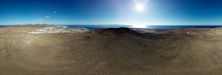
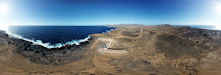
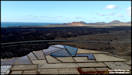
Views around Playa Blanca
in the first week of our trip.
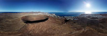
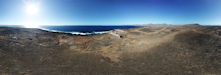
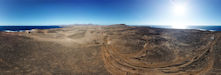
  This day's trip didn't
go quite as planned! Pulling off the side of the road at my first
planned location I managed to hit one of the incredibly sharp volcanic
rocks used to delineate the edge of the road area and puncture a tyre.
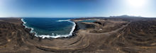
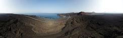
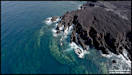
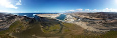
With no spare wheel in the hire car I had to wait to be rescued and these
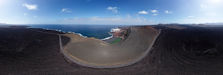
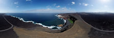
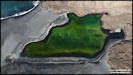
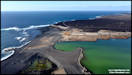
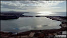
pics were taken waiting for them to arrive. Location is Charco de
los Clicos near El Golfo, where there is a partially collapsed volcano
cone on the shore, enclosing a green lagoon.
This day's trip didn't
go quite as planned! Pulling off the side of the road at my first
planned location I managed to hit one of the incredibly sharp volcanic
rocks used to delineate the edge of the road area and puncture a tyre.
With no spare wheel in the hire car I had to wait to be rescued and these
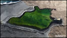
pics were taken waiting for them to arrive. Location is Charco de
los Clicos near El Golfo, where there is a partially collapsed volcano
cone on the shore, enclosing a green lagoon.
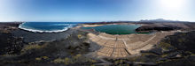
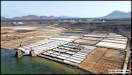
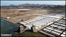
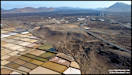
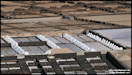
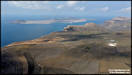
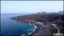
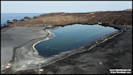
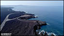
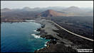
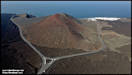
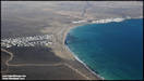
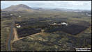
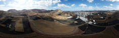
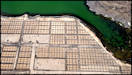
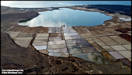
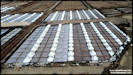
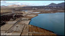
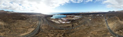
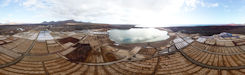
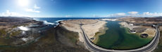
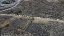
 Not far from Playa Blanca
is the Salinas de Janubio, a saltworks where sea salt is extracted and
produced using traditional methods. There were once many such salt
works around the coast in Lanzarote, but I think this is the last one still
in operation although the remains of many others can still be seen, in
some cases converted for use in hotels. Only a small portion of the
salinas is still in use these days. Just south of the saltworks is
an installation that reverses the process, fresh water is at a premium
in Lanzarote, so much of the water used is processed from sea water at
the de-salination plant.
Not far from Playa Blanca
is the Salinas de Janubio, a saltworks where sea salt is extracted and
produced using traditional methods. There were once many such salt
works around the coast in Lanzarote, but I think this is the last one still
in operation although the remains of many others can still be seen, in
some cases converted for use in hotels. Only a small portion of the
salinas is still in use these days. Just south of the saltworks is
an installation that reverses the process, fresh water is at a premium
in Lanzarote, so much of the water used is processed from sea water at
the de-salination plant.
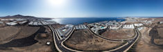
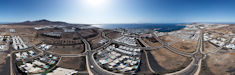
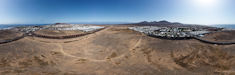
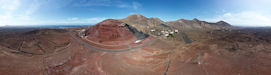
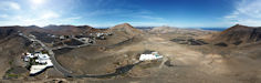
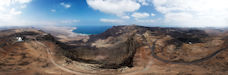
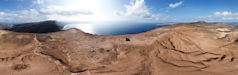
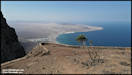
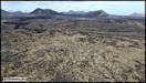
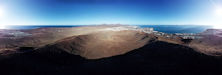
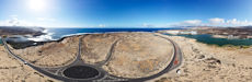
     My next aerial photography
sortie was again not far from Playa Blanca, indeed we can see this area
from the back garden of the villa. It was up in the mountains to
the north east that surround the village of Femes, rising to over 2,000
feet above sea level. A couple of initial locations near Femes before
heading to the other end of the valley at Las Casitas.
My next aerial photography
sortie was again not far from Playa Blanca, indeed we can see this area
from the back garden of the villa. It was up in the mountains to
the north east that surround the village of Femes, rising to over 2,000
feet above sea level. A couple of initial locations near Femes before
heading to the other end of the valley at Las Casitas.
 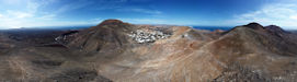
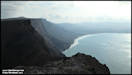
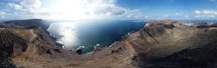
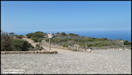
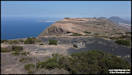
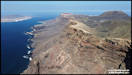
  We have a favourite
trip in Lanzarote, to some of the highest points you can drive to on the
island, the top of the cliffs behind Famara Beach that rise to over 2,000
feet above sea level. We usually follow an unsurfaced road from close to
Teguise and follow it up the little church at Las Nieves where there are
amazing views down to the sea at Famara and, depending on the visibility,
for large distances in many directions.
We have a favourite
trip in Lanzarote, to some of the highest points you can drive to on the
island, the top of the cliffs behind Famara Beach that rise to over 2,000
feet above sea level. We usually follow an unsurfaced road from close to
Teguise and follow it up the little church at Las Nieves where there are
amazing views down to the sea at Famara and, depending on the visibility,
for large distances in many directions.
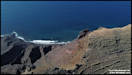
 After taking in the
views and often having a walk around the area we normally drop down to
Haria for lunch before continuing our 'high ground' tour, but on this day
stopped close to the Mirador de Haria for another flight. The cafe/restuarant
here was always popular in the past with coach tours, but they all seemed
to be passing by despite a lot of renovation work having taken place, maybe
the prices are too high or they're charging for parking? There was
apparently also a sign by the cafe saying 'No Drones', but I wasn't flying
from there but around 100 metres further up the road!
After taking in the
views and often having a walk around the area we normally drop down to
Haria for lunch before continuing our 'high ground' tour, but on this day
stopped close to the Mirador de Haria for another flight. The cafe/restuarant
here was always popular in the past with coach tours, but they all seemed
to be passing by despite a lot of renovation work having taken place, maybe
the prices are too high or they're charging for parking? There was
apparently also a sign by the cafe saying 'No Drones', but I wasn't flying
from there but around 100 metres further up the road!
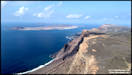
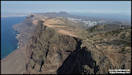
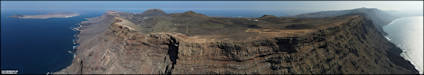
   Continuing with our
'high ground' trip after lunch in Arrieta (a change from the plan!) taking
the unsurfaced road from Maguez back up to the cliff tops then continuing
down into the Valle de Guinate before heading back to Playa Blanca.
One of the features on this section, apart from the stunning scenery, is
the aeronautical radio beacon here, a VOR/DME for my aviation friends,
coding 'LZR'.
Continuing with our
'high ground' trip after lunch in Arrieta (a change from the plan!) taking
the unsurfaced road from Maguez back up to the cliff tops then continuing
down into the Valle de Guinate before heading back to Playa Blanca.
One of the features on this section, apart from the stunning scenery, is
the aeronautical radio beacon here, a VOR/DME for my aviation friends,
coding 'LZR'.
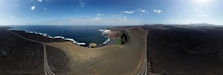
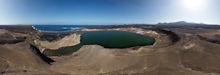
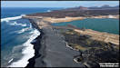
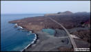
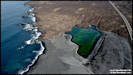
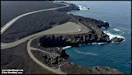
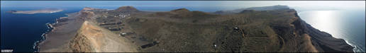
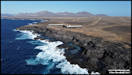
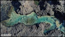
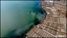
 The black volcanic beach
of Playa de Montana Bermeja (Beach of the Vermilion Mountain) which is
just south of El Golfo. The beach traps a lagoon behind it, which
changes in size over the season and has some fascinating colours, which
change with the viewing angle. I only shot one 360 panorama, so I'm
starting with that and then going onto single shots, finishing with a manually
shot linear panorama.
The black volcanic beach
of Playa de Montana Bermeja (Beach of the Vermilion Mountain) which is
just south of El Golfo. The beach traps a lagoon behind it, which
changes in size over the season and has some fascinating colours, which
change with the viewing angle. I only shot one 360 panorama, so I'm
starting with that and then going onto single shots, finishing with a manually
shot linear panorama.
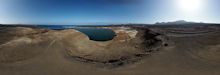
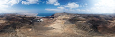
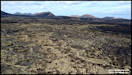
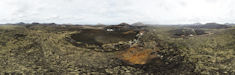
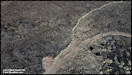
 After leaving the Playa
de Montana Bermeja, I stopped at a location just to the east of El Golfo
where there a a few volcano cones and a lava field. A lot of the land that
wasn't covered by lava shows signs of cultivation, such as defined fields
and stone semi-circles for growing vines. It doesn't look like it's
been used for many years and as the landscape on Lanzarote changes very
little without human intervention, I wonder if this land use pre-dates
the volcanic eruptions.
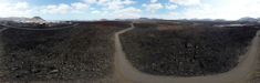
After leaving the Playa
de Montana Bermeja, I stopped at a location just to the east of El Golfo
where there a a few volcano cones and a lava field. A lot of the land that
wasn't covered by lava shows signs of cultivation, such as defined fields
and stone semi-circles for growing vines. It doesn't look like it's
been used for many years and as the landscape on Lanzarote changes very
little without human intervention, I wonder if this land use pre-dates
the volcanic eruptions.
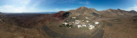
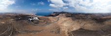
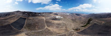
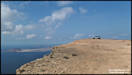
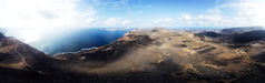
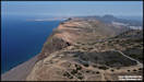
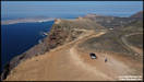
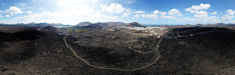
  Another day and another
trip to the high ground above Famara on the north west coast of the island.
This time we started with a visit to Parque El Bosquecillo, which is a
picnic area to the north of the radar station. It's reached by a
rather narrow unsurfaced road, whose condition can be variable, but once
there the car park is paved and there are swings and slides for kids, picnic
benches and barbecue areas. The views even from ground level are
stunning!
Another day and another
trip to the high ground above Famara on the north west coast of the island.
This time we started with a visit to Parque El Bosquecillo, which is a
picnic area to the north of the radar station. It's reached by a
rather narrow unsurfaced road, whose condition can be variable, but once
there the car park is paved and there are swings and slides for kids, picnic
benches and barbecue areas. The views even from ground level are
stunning!
    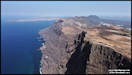
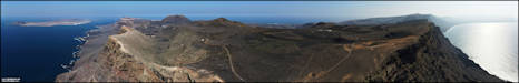
   After lunch in Haria
we continued our high ground trip, taking the road up from Maguez to the
top of the Valle de Guinate, where the are some great views again.
I didn't shoot any 360 panoramas there but I did several manual 'linear'
ones.
After lunch in Haria
we continued our high ground trip, taking the road up from Maguez to the
top of the Valle de Guinate, where the are some great views again.
I didn't shoot any 360 panoramas there but I did several manual 'linear'
ones.
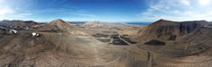
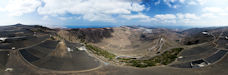
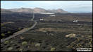
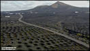
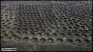
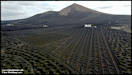
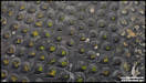
 My next trip out for
aerial photography was to the major wine producing area of La Geria. Although
it was sunny in Playa Blanca, it was more or less overcast when I arrived
there, which was not ideal for photographing areas where the predominant
colour is black, as the vines are grown on crushed volcanic rock, which
extracts moisture from the air overnight to nourish the vines. The
area is generally over 1,000ft above sea level and the vines are protected
by low stone walls.
My next trip out for
aerial photography was to the major wine producing area of La Geria. Although
it was sunny in Playa Blanca, it was more or less overcast when I arrived
there, which was not ideal for photographing areas where the predominant
colour is black, as the vines are grown on crushed volcanic rock, which
extracts moisture from the air overnight to nourish the vines. The
area is generally over 1,000ft above sea level and the vines are protected
by low stone walls.
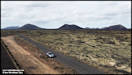
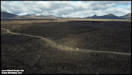
 Continuing onwards from
La Geria, took the minor road leading north from Masdache towards
La Vegueta, hoping to capture some of the green lichen covered lava fields
that formed into huge broken slabs, interspersed by areas that have been
cleared for cultivation. After conducting a flight there I continued
onwards, stopping for a final flight in the area of Montana Tizolaya, another
dormant volcano cone.
Continuing onwards from
La Geria, took the minor road leading north from Masdache towards
La Vegueta, hoping to capture some of the green lichen covered lava fields
that formed into huge broken slabs, interspersed by areas that have been
cleared for cultivation. After conducting a flight there I continued
onwards, stopping for a final flight in the area of Montana Tizolaya, another
dormant volcano cone.
  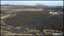  
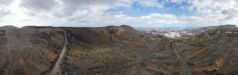
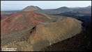
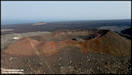
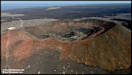
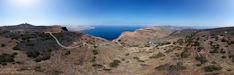
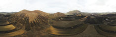
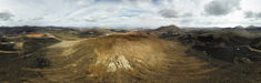
 Montana Tizolaya
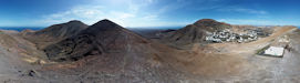
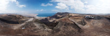
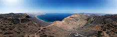
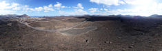
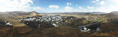
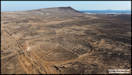
   This aerial photo detail
was to concentrate on the area around Yaiza, the administrative town for
the south of Lanzarote. The area available for flying to the north
of Yaiza is limited by the Restricted Area around the Timanfaya National
Park.
This aerial photo detail
was to concentrate on the area around Yaiza, the administrative town for
the south of Lanzarote. The area available for flying to the north
of Yaiza is limited by the Restricted Area around the Timanfaya National
Park.
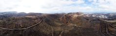
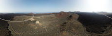
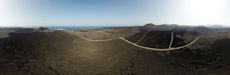
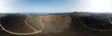
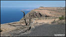
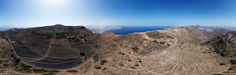
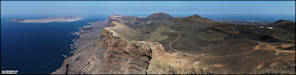
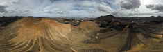
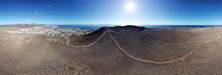
  Four 360 panoramas shot
during a walk up the Montana Roja volcano cone in Playa Blanca. It
was fairly calm at the start of the walk, but quite breezy by
the time we had walked
around the rim to the west side, where the second two panoramas were shot
from.
Four 360 panoramas shot
during a walk up the Montana Roja volcano cone in Playa Blanca. It
was fairly calm at the start of the walk, but quite breezy by
the time we had walked
around the rim to the west side, where the second two panoramas were shot
from.
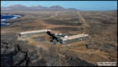
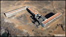
 This building has fascinated
me since our first visit to Lanzarote, it's the hotel Atlante del Sol,
which was constructed in the 1970s but never completed. I've seen
several different stories about it, one that it was going to be a golf
resort constructed in the desert by a German company - until they realised
that it would be impossible to grow grass here! Another is that one of
the investors 'vanished' with all the money before it was completed. A
third version was that the company never had the required permits to construct
it, all sound plausible reasons. There are some amazing tidal pools in
the rocks that invite swimmers, but extreme caution is advised as big Atlantic
waves can sweep right over them without warning.
This building has fascinated
me since our first visit to Lanzarote, it's the hotel Atlante del Sol,
which was constructed in the 1970s but never completed. I've seen
several different stories about it, one that it was going to be a golf
resort constructed in the desert by a German company - until they realised
that it would be impossible to grow grass here! Another is that one of
the investors 'vanished' with all the money before it was completed. A
third version was that the company never had the required permits to construct
it, all sound plausible reasons. There are some amazing tidal pools in
the rocks that invite swimmers, but extreme caution is advised as big Atlantic
waves can sweep right over them without warning.
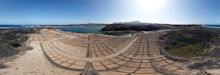
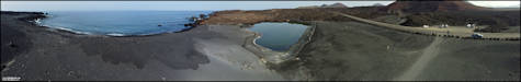
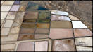
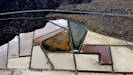
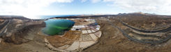
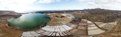
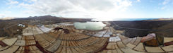
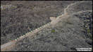
   Colours and shapes at
the saltworks. Re-visiting the Salinas de Janubio in the afternoon.
Colours and shapes at
the saltworks. Re-visiting the Salinas de Janubio in the afternoon.
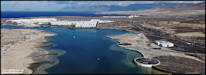
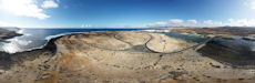
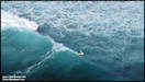
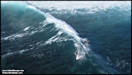
  We were almost at the
end of our Lanzarote visit when we decided to visit the La Santa area in
the north west of the island. The village of La Santa is a traditional
fishing village where some excellent fresh seafood can be bought in the
restaurants, but this time we went to La Isleta, a tiny sandy island separated
from the mainland by El Rio, a tidal inlet that I think had been dammed
and converted to a Salinas, before it's present use as beach and lagoon.
The island itself is sandy and barren, but rather strangely has a network
of tarmac roads around it. Just to the north is Club La Santa, a rather
exclusive (expensive?) sports based hotel. The inlet to the south
of the island is popular with surfers, as the Atlantic waves are funnelled
into a small area, making some good surfing conditions.
We were almost at the
end of our Lanzarote visit when we decided to visit the La Santa area in
the north west of the island. The village of La Santa is a traditional
fishing village where some excellent fresh seafood can be bought in the
restaurants, but this time we went to La Isleta, a tiny sandy island separated
from the mainland by El Rio, a tidal inlet that I think had been dammed
and converted to a Salinas, before it's present use as beach and lagoon.
The island itself is sandy and barren, but rather strangely has a network
of tarmac roads around it. Just to the north is Club La Santa, a rather
exclusive (expensive?) sports based hotel. The inlet to the south
of the island is popular with surfers, as the Atlantic waves are funnelled
into a small area, making some good surfing conditions.
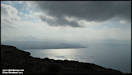
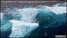
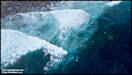
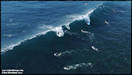
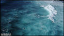
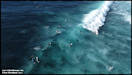
 Starting with some vertical
views of the waves just off the island. These are 'HDR' shots combined
from three bracketed aexposure originals.
Starting with some vertical
views of the waves just off the island. These are 'HDR' shots combined
from three bracketed aexposure originals.
    Interactive 360 Panoramas
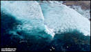
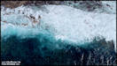
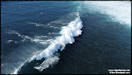
 After shooting the first
set of pictures I landed to change to a fresh battery and then tried another
flight to see if I could capture the surfers from a low level, without
endangering either the drone or them! I think that I flew down to
a minimum of 50 feet altitude and was carefull to keep a good distance
fromthe surfers.
After shooting the first
set of pictures I landed to change to a fresh battery and then tried another
flight to see if I could capture the surfers from a low level, without
endangering either the drone or them! I think that I flew down to
a minimum of 50 feet altitude and was carefull to keep a good distance
fromthe surfers.
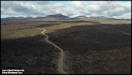
   On the way back from
La Santa to Playa Blanca we drove through the Tymanfaya Volcano park in
the afternoon and I was hooing to see some of the camels on their way back
from the camel rides station to the farms between Yaiza and Uga.
They and their handlers walk the the four miles out in the morning, spend
the day providing rides and then walk back in the afternoon. There
were no camels at the rides station and we didn't see any until just before
we got to the roundabout outside Yaiza. I think these were the last
to return that day.
On the way back from
La Santa to Playa Blanca we drove through the Tymanfaya Volcano park in
the afternoon and I was hooing to see some of the camels on their way back
from the camel rides station to the farms between Yaiza and Uga.
They and their handlers walk the the four miles out in the morning, spend
the day providing rides and then walk back in the afternoon. There
were no camels at the rides station and we didn't see any until just before
we got to the roundabout outside Yaiza. I think these were the last
to return that day.
|